

As of 21 Nov 2026, iSailGPS : NOAA USA RNC Charts is #90 in Paid · Navigation in the United States, the one tracked chart it's in. Its best rank in the last 7 days was #33 in Paid · Navigation in the United States. Appulse Index first saw iSailGPS : NOAA USA RNC Charts in a tracked chart on 8 Oct 2026. Since then it has charted on 13 days in 1 country, with a best rank of #33 in Paid · Navigation in the United States on 19 Nov 2026.
Current rank
#90United States · Paid · Navigation
- Was
- —7 days ago
- Change
- Not enough history yetover 7 days
- Best
- #33in 7 days
- Longest chart run
- 13 daysUnited States · Paid · Navigation
- New ratings, 7 days
- —Needs a week of rating history
Chart record
Every tracked chart, country and day since Appulse Index first saw this app in a chart.
What's new
Version 9.6.9 · 6 months ago
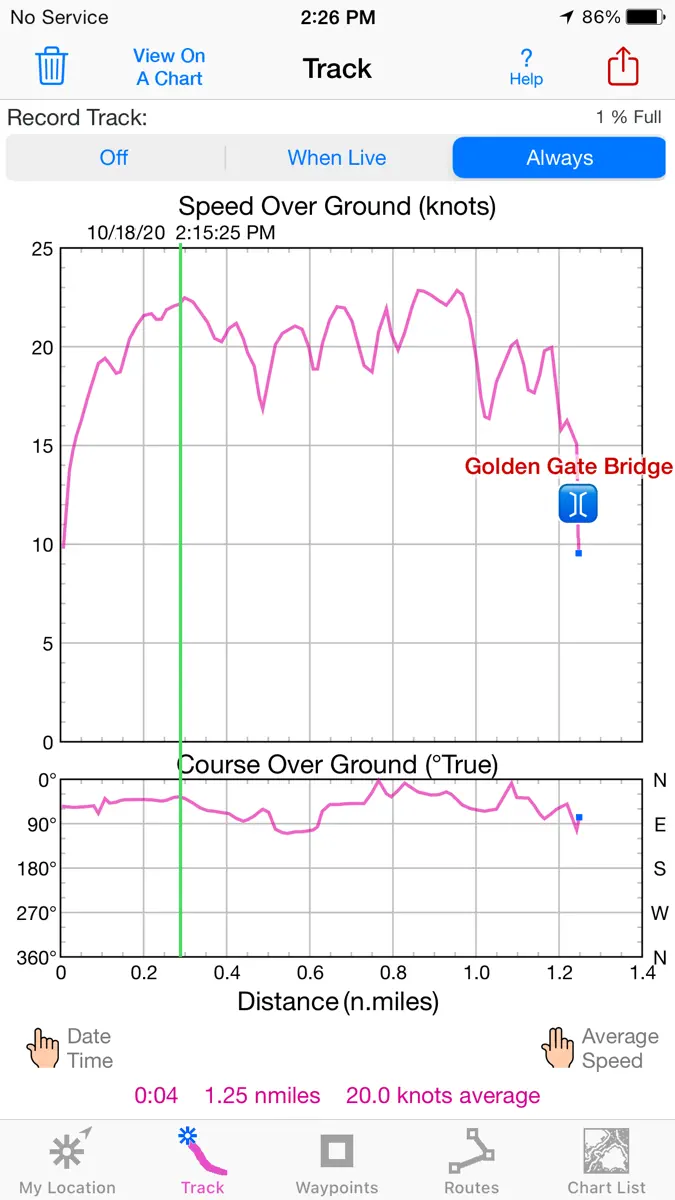
Improved wording on some Alerts and Notifications. What's new in iSailGPS when compared with other available NOAA chart apps? • You don't just see Waypoints and Routes displayed on the chart, you can actually do real great circle navigation to those Waypoints and along those Routes. You get information such as Estimated Time of Arrival, current bearing, heading and cross-track error, and remaining distances to your intermediate and final destinations. • You don't just see individual charts. Whenever the map projection is compatible (which it is most cases), you can see adjacent charts with their margins removed stitched together seamlessly, even when the chart scales are different. For example you can see the approach chart and the corresponding harbor detail chart both together on the same screen. • You can create, import, edit, export, and navigate both on routes based on a recorded or imported path, and on routes based on a series of waypoints. • Get the weather report and forecast, the sun and moon position, rise and set times, and driving directions to the dock for any point on a chart with a few taps. • iSailGPS's code size is kept very small by efficient programming so in an emergency, you can download it easily even over a weak cell connection. • The current version of iSailGPS runs on the latest devices and also on older devices with older versions of iOS , all the way back to devices such as the iPhone 6. • There is never any confusion over what charts you have available offline. They are clearly listed by NOAA chart name and number, and shown on an overview map. • Check the App Privacy section. We don't know who you are when you are using iSailGPS. We never send your current location or your recorded track to our servers. Hence we cannot and don't use your location data. We cannot and don't provide your location data to anyone else. Unlike other mapping apps that profit from using your location data in ways that do not keep it private, iSailGPS maintains the highest level of data confidentially.
Ranking events
- Dropped #44 → #90 in Paid · NavigationUnited States
- Entered the Paid · Navigation chart at #33United States
- Entered the Paid · Navigation chart at #76United States
- Dropped #71 → #97 in Paid · NavigationUnited States
- Entered the Paid · Navigation chart at #71United States
- Entered the Paid · Navigation chart at #75United States
Show 5 earlier events
- Entered the Paid · Navigation chart at #54United States
- Entered the Paid · Navigation chart at #34United States
- Climbed #67 → #34 in Paid · NavigationUnited States
- Entered the Paid · Navigation chart at #62United States
- Dropped #62 → #87 in Paid · NavigationUnited States
About
Unleash the navigation potential of your iPhone or iPad with SailGPS! Turn your device into a high-performance GPS receiver with USA NOAA Raster Nautical Charts, even without a cell signal! Rated “Best Choice — Excellent” by Practical-Sailor.com Caught in a storm on the water and your chart plotter fails? Don't worry! Download this app now and regain full navigation capabilities to safely return to port. Better yet, buy iSailGPS today ensuring you're prepared for any situation, even in areas…
Ranks come from Apple's public App Store charts, checked once a day. Appulse Index isn't affiliated with Apple.
Rank history
Higher on the chart is better: #1 is at the top.
Sign in to see 30 days, 90 days and all history.
United States · Paid · Navigation: best #33, latest #90, over 7 snapshots since 15 Nov.
In 1 chart now
| Chart | Rank | 24 h | 7 days | Best | Days on chart |
|---|---|---|---|---|---|
| United States· Paid · Navigation · best #33 · 13 days | #90 | Down 46 places | Not enough history yet | #33 | 13 |
Competitors
Compare with the top 3Full chartTop of Paid · Navigation in United States. iSailGPS : NOAA USA RNC Charts is #90 there. Changes are over 7 days.
- #1 (number one)No change
 MilGPSCascode Labs Pty Ltd
- #2No change
 Solocator - GPS Field CameraCivi Corp
- #3No change
 Land Nav AssistantGammon Applications, LLC
- #4Up 1 place
 Blitzer.de PROEifrig Media
- #5Down 1 place
 Sporty's E6B Flight ComputerSporty's Pilot Shop
- #6Up 35 places
 Wasatch Backcountry Skiing MapIterum, LLC
- #7No change
 Find93Paul Kragthorpe
- #8Down 2 places
- #9No change
 TheodoliteCraig Hunter
- #10Up 2 places
 aprs.fiGainIO
- #11Up 36 places
 Pro Night — Night Vision AppViktor Pobedria
- #12Up 2 places
 NZ Topo50 South IslandRight Place Resources
- #13Down 5 places
 TACNAV-X: Military NavigationTacNav Systems LLC
- #14Up 38 places
 FlightReady E6BAeroapps Technology
- #15New entry
 Qiblanuma: Qibla DirectionSUPERSONIC BYTE Sarajevo
- #16Up 2 places
 Holding Pattern TrainerFLEMINGER MEDIA LLC
- #17Up 41 places
 Bronx Zoo - ZooMapChalkLink, LLC
- #18Up 7 places
 Speedometer 55 Pro. GPS kit.Stanislav Dvoychenko
- #19Not enough history yet
 Montana 511 Traffic CamerasLW Brands, LLC
- #20Not enough history yet
 Pro Altimeter - Barometric+GPSCraig Hunter

Screenshots



More from James Associates Inc.
| App | Best rank now | Released | App Store |
|---|---|---|---|
 iHikeGPS NZ : LINZ Topo MapsNavigation · | Paid · NavigationAustralia#69 | ||
 iHikeGPS : Classic Topo MapsNavigation · | Paid · NavigationCanada#76 | ||
 iSailGPS NZ : Nautical ChartsNavigation · | Not charting |

As of 21 Nov 2026, iSailGPS : NOAA USA RNC Charts is #90 in Paid · Navigation in the United States, the one tracked chart it's in. Its best rank in the last 7 days was #33 in Paid · Navigation in the United States. Appulse Index first saw iSailGPS : NOAA USA RNC Charts in a tracked chart on 8 Oct 2026. Since then it has charted on 13 days in 1 country, with a best rank of #33 in Paid · Navigation in the United States on 19 Nov 2026.
Store listing
How the app presents itself on the App Store. Select a screenshot to open it full size.
App facts
What Apple publishes about this app. Ratings are from one country's App Store.
- Price
- $7.99
- Rating
- 3.9 / 5 stars72 ratings United States
- Released
- 29 Apr 2011
- Last update
- Version 9.6.9
- Requires
- iOS 12.0or later
- Size
- 10.9 MB
- Languages
- 1
Chart record
Every tracked chart, country and day since Appulse Index first saw this app in a chart.
Rank history
Higher on the chart is better: #1 is at the top.
Sign in to see 30 days, 90 days and all history.
United States · Paid · Navigation: best #33, latest #90, over 7 snapshots since 15 Nov.
Current rankings
Every chart this app is in right now, best position first.
| Chart | Rank | 24 h | 7 days | Best | Days on chart |
|---|---|---|---|---|---|
| United States· Paid · Navigation · best #33 · 13 days | #90 | Down 46 places | Not enough history yet | #33 | 13 |
Ranking events
Entries, big moves, #1s and new versions we've recorded, by day.
- Dropped #44 → #90 in Paid · NavigationUnited States
- Entered the Paid · Navigation chart at #33United States
- Entered the Paid · Navigation chart at #76United States
- Dropped #71 → #97 in Paid · NavigationUnited States
- Entered the Paid · Navigation chart at #71United States
- Entered the Paid · Navigation chart at #75United States
- Entered the Paid · Navigation chart at #54United States
- Entered the Paid · Navigation chart at #34United States
- Climbed #67 → #34 in Paid · NavigationUnited States
- Entered the Paid · Navigation chart at #62United States
- Dropped #62 → #87 in Paid · NavigationUnited States
Competitors
Compare with the top 3Full chartTop of Paid · Navigation in United States. iSailGPS : NOAA USA RNC Charts is #90 there. Changes are over 7 days.
- #1 (number one)No changeMilGPSCascode Labs Pty Ltd
- #2No changeSolocator - GPS Field CameraCivi Corp
- #3No changeLand Nav AssistantGammon Applications, LLC
- #4Up 1 placeBlitzer.de PROEifrig Media
- #5Down 1 placeSporty's E6B Flight ComputerSporty's Pilot Shop
- #6Up 35 placesWasatch Backcountry Skiing MapIterum, LLC
- #7No changeFind93Paul Kragthorpe
- #8Down 2 places
- #9No changeTheodoliteCraig Hunter
- #10Up 2 placesaprs.fiGainIO
- #11Up 36 placesPro Night — Night Vision AppViktor Pobedria
- #12Up 2 placesNZ Topo50 South IslandRight Place Resources
- #13Down 5 placesTACNAV-X: Military NavigationTacNav Systems LLC
- #14Up 38 placesFlightReady E6BAeroapps Technology
- #15New entryQiblanuma: Qibla DirectionSUPERSONIC BYTE Sarajevo
- #16Up 2 placesHolding Pattern TrainerFLEMINGER MEDIA LLC
- #17Up 41 placesBronx Zoo - ZooMapChalkLink, LLC
- #18Up 7 placesSpeedometer 55 Pro. GPS kit.Stanislav Dvoychenko
- #19Not enough history yetMontana 511 Traffic CamerasLW Brands, LLC
- #20Not enough history yetPro Altimeter - Barometric+GPSCraig Hunter
- #90Not enough history yet
 iSailGPS : NOAA USA RNC ChartsThis app
About
From the app's App Store listing.
Unleash the navigation potential of your iPhone or iPad with SailGPS! Turn your device into a high-performance GPS receiver with USA NOAA Raster Nautical Charts, even without a cell signal!
Rated “Best Choice — Excellent” by Practical-Sailor.com
Caught in a storm on the water and your chart plotter fails? Don't worry! Download this app now and regain full navigation capabilities to safely return to port. Better yet, buy iSailGPS today ensuring you're prepared for any situation, even in areas…
What's new
Version 9.6.9 · 24 Apr 2026 ·
Improved wording on some Alerts and Notifications.
What's new in iSailGPS when compared with other available NOAA chart apps?
- You don't just see Waypoints and Routes displayed on the chart, you can actually do real great circle navigation to those Waypoints and along those Routes. You get information such as Estimated Time of Arrival, current bearing, heading and cross-track error, and remaining distances to your intermediate and final destinations.
- You don't just see individual charts. Whenever the map projection is compatible (which it is most cases), you can see adjacent charts with their margins removed stitched together seamlessly, even when the chart scales are different. For example you can see the approach chart and the corresponding harbor detail chart both together on the same screen.
- You can create, import, edit, export, and navigate both on routes based on a recorded or imported path, and on routes based on a series of waypoints.
- Get the weather report and forecast, the sun and moon position, rise and set times, and driving directions to the dock for any point on a chart with a few taps.
- iSailGPS's code size is kept very small by efficient programming so in an emergency, you can download it easily even over a weak cell connection.
- The current version of iSailGPS runs on the latest devices and also on older devices with older versions of iOS , all the way back to devices such as the iPhone 6.
- There is never any confusion over what charts you have available offline. They are clearly listed by NOAA chart name and number, and shown on an overview map.
- Check the App Privacy section. We don't know who you are when you are using iSailGPS. We never send your current location or your recorded track to our servers. Hence we cannot and don't use your location data. We cannot and don't provide your location data to anyone else. Unlike other mapping apps that profit from using your location data in ways that do not keep it private, iSailGPS maintains the highest level of data confidentially.
More from James Associates Inc.
Their other apps that Appulse has seen in the charts, charting ones first.
| App | Best rank now | Released | App Store |
|---|---|---|---|
iHikeGPS NZ : LINZ Topo MapsNavigation · | Paid · NavigationAustralia#69 | ||
iHikeGPS : Classic Topo MapsNavigation · | Paid · NavigationCanada#76 | ||
iSailGPS NZ : Nautical ChartsNavigation · | Not charting |
Ranks come from Apple's public App Store charts, checked once a day. Appulse Index isn't affiliated with Apple.