

Appulse Index first saw MeasureGeo in a tracked chart on 1 Nov 2026. Since then it has charted on 1 day in 1 country, with a best rank of #84 in Paid · Navigation in the United States on 1 Nov 2026.
Not charting right now
This app isn't in any tracked top 100 at the moment.
- Longest chart run
- —Counted while Appulse tracks it
- New ratings, 7 days
- —Needs a week of rating history
Chart record
Every tracked chart, country and day since Appulse Index first saw this app in a chart.
What's new
Version 1.0.1 · 23 days ago
Elevation profiles now use USGS 3DEP in the United States and AWS Terrain Tiles elsewhere. Draw a line to see gain, loss, high and low points and a chart, with the data source named under it. A new Privacy button on the map opens the privacy policy.
Ranking events
- Entered the Paid · Navigation chart at #84United States
About
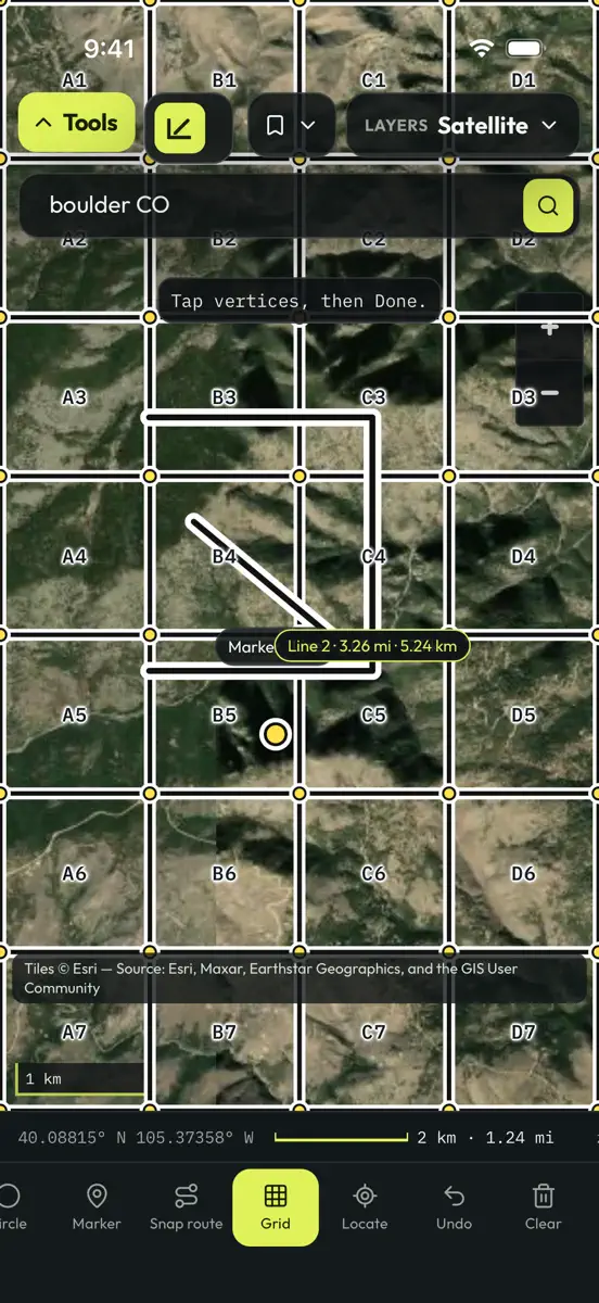
MeasureGeo is a field map toolkit. Draw and measure polygons and lines, drop a GRG grid on the view, and leave with an export. Search for a place or a coordinate and go there. Switch basemaps among Esri street and imagery, CycleOSM, OpenTopoMap, and USGS topo. Google and Bing tiles are not included. Print a field sheet of the map and the measurements. Export KML, GeoJSON, GPX, or a shapefile, then use Send to… to hand the file to another app. Drawings stay on this device. There is no account…
Ranks come from Apple's public App Store charts, checked once a day. Appulse Index isn't affiliated with Apple.
Current rankings
Not charting right now
This app isn't in any tracked top 100 at the moment. Its history shows when it was.
Competitors
Compare with the top 3Full chartTop of Paid · Navigation in United States. MeasureGeo isn't in it right now. Changes are over 7 days.
- #1 (number one)No change
 MilGPSCascode Labs Pty Ltd
- #2No change
 Solocator - GPS Field CameraCivi Corp
- #3No change
 Land Nav AssistantGammon Applications, LLC
- #4Up 1 place
 Blitzer.de PROEifrig Media
- #5Down 1 place
 Sporty's E6B Flight ComputerSporty's Pilot Shop
- #6Up 35 places
 Wasatch Backcountry Skiing MapIterum, LLC
- #7No change
 Find93Paul Kragthorpe
- #8Down 2 places
- #9No change
 TheodoliteCraig Hunter
- #10Up 2 places
 aprs.fiGainIO
- #11Up 36 places
 Pro Night — Night Vision AppViktor Pobedria
- #12Up 2 places
 NZ Topo50 South IslandRight Place Resources
- #13Down 5 places
 TACNAV-X: Military NavigationTacNav Systems LLC
- #14Up 38 places
 FlightReady E6BAeroapps Technology
- #15New entry
 Qiblanuma: Qibla DirectionSUPERSONIC BYTE Sarajevo
- #16Up 2 places
 Holding Pattern TrainerFLEMINGER MEDIA LLC
- #17Up 41 places
 Bronx Zoo - ZooMapChalkLink, LLC
- #18Up 7 places
 Speedometer 55 Pro. GPS kit.Stanislav Dvoychenko
- #19Not enough history yet
 Montana 511 Traffic CamerasLW Brands, LLC
- #20Not enough history yet
 Pro Altimeter - Barometric+GPSCraig Hunter

Screenshots



More from MARSHALL TYLER FRITH
| App | Best rank now | Released | App Store |
|---|---|---|---|
 Bathymetry MapsNavigation · | Paid · NavigationUnited States#28 | ||
 ChangeLens EarthNavigation · | Not charting | ||
 Deer AwarenessSports · | Not charting | ||
 Sentinel-2 Clear DaysNavigation · | Not charting |

Appulse Index first saw MeasureGeo in a tracked chart on 1 Nov 2026. Since then it has charted on 1 day in 1 country, with a best rank of #84 in Paid · Navigation in the United States on 1 Nov 2026.
Store listing
How the app presents itself on the App Store. Select a screenshot to open it full size.
App facts
What Apple publishes about this app. Ratings are from one country's App Store.
- Price
- $0.99
- Released
- 16 Oct 2026
- Last update
- Version 1.0.1
- Requires
- iOS 16.0or later
- Size
- 3.7 MB
- Languages
- 1
Chart record
Every tracked chart, country and day since Appulse Index first saw this app in a chart.
Rank history
Higher on the chart is better: #1 is at the top.
No chart history to show
History appears for charts the app is currently in.
Current rankings
Every chart this app is in right now, best position first.
Not charting right now
This app isn't in any tracked top 100 at the moment. Its history shows when it was.
Ranking events
Entries, big moves, #1s and new versions we've recorded, by day.
- Entered the Paid · Navigation chart at #84United States
Competitors
Compare with the top 3Full chartTop of Paid · Navigation in United States. MeasureGeo isn't in it right now. Changes are over 7 days.
- #1 (number one)No changeMilGPSCascode Labs Pty Ltd
- #2No changeSolocator - GPS Field CameraCivi Corp
- #3No changeLand Nav AssistantGammon Applications, LLC
- #4Up 1 placeBlitzer.de PROEifrig Media
- #5Down 1 placeSporty's E6B Flight ComputerSporty's Pilot Shop
- #6Up 35 placesWasatch Backcountry Skiing MapIterum, LLC
- #7No changeFind93Paul Kragthorpe
- #8Down 2 places
- #9No changeTheodoliteCraig Hunter
- #10Up 2 placesaprs.fiGainIO
- #11Up 36 placesPro Night — Night Vision AppViktor Pobedria
- #12Up 2 placesNZ Topo50 South IslandRight Place Resources
- #13Down 5 placesTACNAV-X: Military NavigationTacNav Systems LLC
- #14Up 38 placesFlightReady E6BAeroapps Technology
- #15New entryQiblanuma: Qibla DirectionSUPERSONIC BYTE Sarajevo
- #16Up 2 placesHolding Pattern TrainerFLEMINGER MEDIA LLC
- #17Up 41 placesBronx Zoo - ZooMapChalkLink, LLC
- #18Up 7 placesSpeedometer 55 Pro. GPS kit.Stanislav Dvoychenko
- #19Not enough history yetMontana 511 Traffic CamerasLW Brands, LLC
- #20Not enough history yetPro Altimeter - Barometric+GPSCraig Hunter
About
From the app's App Store listing.
MeasureGeo is a field map toolkit. Draw and measure polygons and lines, drop a GRG grid on the view, and leave with an export.
Search for a place or a coordinate and go there. Switch basemaps among Esri street and imagery, CycleOSM, OpenTopoMap, and USGS topo. Google and Bing tiles are not included. Print a field sheet of the map and the measurements.
Export KML, GeoJSON, GPX, or a shapefile, then use Send to… to hand the file to another app. Drawings stay on this device. There is no account…
What's new
Version 1.0.1 · 28 Oct 2026 ·
Elevation profiles now use USGS 3DEP in the United States and AWS Terrain Tiles elsewhere. Draw a line to see gain, loss, high and low points and a chart, with the data source named under it.
A new Privacy button on the map opens the privacy policy.
More from MARSHALL TYLER FRITH
Their other apps that Appulse has seen in the charts, charting ones first.
| App | Best rank now | Released | App Store |
|---|---|---|---|
Bathymetry MapsNavigation · | Paid · NavigationUnited States#28 | ||
ChangeLens EarthNavigation · | Not charting | ||
Deer AwarenessSports · | Not charting | ||
Sentinel-2 Clear DaysNavigation · | Not charting |
Ranks come from Apple's public App Store charts, checked once a day. Appulse Index isn't affiliated with Apple.